Yellow Aster Butte Trail, WA
Vicinity Location:
About 240 miles north of Portland, OR and about 135 miles northeast of Seattle in the Mt. Baker Wilderness.
Directions:
From Portland: Drive about 300 miles and 5.5 to 6.5 hours through Seattle.
From Seattle: Drive on I-5 for about 240 miles and take exit 232 for Sedro-Woolley. Drive 5.2 miles to Sedro-Woolley and take Hwy 9 North for 30.5 miles to Hwy 542.
Take Hwy 542 East for 31.7 miles driving through Maple Falls and other communities and turn left onto FR NF-3065 and drive 4.3 miles to the trailhead area.
There is a pit toilet bathroom at the trailhead.
A Northwest Forest Permit or equivalent is required to park.
Blue bags or equivalent are required and you are required to pack out your feces.
Length and Elevation:
8.6 miles roundtrip. Elevation at the trailhead is 3,675 feet. Total gain is 2,850 feet and loss is 2,850 feet. Highest elevation is 5,732 feet and the lowest elevation 3,675 feet.
Trails:
Tomyhoi Lake Trail 686, Yellow Aster Butte Trail #686.1, with connections to Tomyhoi Peak Trail #686.2.
There is at least one geocache at: N 48° 56.892 W 121° 41.243 Info at Geocaching.com
Trail Maps:
Topo Map, Download Garmin .gpx file, Open Garmin .gpx file
Review: August 17, 2022
Get ready for a glute burner of an ascent. Right out of the trail head you climb several steep switchbacks and then continue steeply along the slope of a mountain ridge.
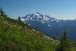
The unrelenting climb at the beginning of this hike leads across open slopes filled with brush, stinging nettle, and several kinds of wildflowers. This first part of the hike is totally exposed to the sun for about the first 2/10 of a mile. On the plus side is that as you climb up the switchbacks you have great views of Mount Baker right away.
Re-enter the forest and traverse the ridge for about 3/10 of the mile on a fairly level section before climbing steeply again and ascending another set of switchbacks.
This first section of trail is a nice dirt trail with just a few rocks and roots. The beautiful forest is a mix hemlock, grand fir, and maybe noble firs. The ages of the trees vary from old growth, to trees 70 to 80 years old, down to young saplings.
With a steep steep climb you eventually reach the junction for Tomyhoi Lake Trail and the Yellow Astor Butee Trail. Turn left here and walk on level trail for about a quarter of a mile.
Where the trail begins to climb again you have excellent views of Mount Shuksan and Mt. Baker. If you are a Verizon or AT&T customer there is cell-service on this stretch of trail. Eventually you will reach a small saddle and then drop in to a small hanging valley where a snowfield lingers through most of the year. Cross the outlet stream on large steppingstones and begin climbing again.
Climb out of the forest along the fireweed lined trail through wildflower filled alpine mountain meadows. Around the bend you can see your destination but there’s still more climbing to do. Pass by great views of Mt. Shuksan and Mount Baker as you near the high point of the trail. Come out to a seasonal tarn then climb more gently through flower filled meadows to the junction of the trail to Yellow Aster Butte. This review skips this trail spur and instead continues to an overlook of the lakes, which are the destination.
Descend from the overlook then drop down several harrowing narrow and short switchbacks to a wide, mostly level saddle containing several lakes. Choose your favorite lake and enjoy. The two northern lakes are a good destination. The larger lake has an excellent lake bottom and even a rock you where you can dive into the lake. There are some trees fairly close to provide shade on a hot day and about 200 feet east of the shady spot is a nice stream to filter water from.
Return up the tight switchbacks and return back to the trailhead on the same trail.
Enjoy the photos!!
Gallery Pics
Switchback Steve
