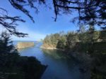
Sunset Bay, OR

Vicinity Location:
About 173 miles southwest of Portland, OR near Shore Acres State Park.
Directions:
From Portland drive to Coos Bay then drive towards Shore Acres State Park. Drive about 1 mile past Sunset Bay and park in the small parking area on the right.
No permits are needed to park here but an Oregon State Park permit is needed at Shore Acres State Park Botanical Gardens.
There are no bathrooms at the parking area. There are bathrooms about 0.75 miles away back towards Charleston and Coos Bay.
Length and Elevation:
2.2 miles roundtrip. Elevation at the trailhead is 30 feet. Total gain is 75 feet and loss is 75 feet. Highest elevation is 50 feet and the lowest elevation sea level.
Trails:
Viewpoint Trail, Norton Gulch Trail with connections to the Oregon Coast Trail.
There is a geocache along the trail at: N 43° 19.783 W 124° 22.823 Info at Geocaching.com
Trail Maps:
Topo Map , Download Garmin .gpx file
Review: December 13, 2023
From the parking lot walk down stairs and head towards the ocean. Turn right and walk through the trees for a short distance then parallel the road to Norton Gulch. In about 0.2 mile take the junction for the Norton Gulch Trail and walk down to a rocky beach in a little cove. The trail crosses Norton Creek on a little wooden bridge then drops down to the beach. Mostly Sitka spruce trees and salal grow along the trail. Coming back from Norton Gulch, turn left and walk back up to the main trail to a large grassy meadow with some picnic tables.
Continue walking towards the ocean on a well-maintained gravelly trail. Most of the trees here are pretty small and the undergrowth consists of a lot of sword ferns and some blackberry bushes. Along the trail and you pass a trail on the left leading to the large grassy meadow.
After about .3 miles from the junction with the Norton Gulch Trail is a trail off to the left that leads to a viewpoint of the ocean and Sunset Bay. You can’t see the lighthouse from this viewpoint.
Wander through a second growth forest and go past another path to the big meadow. Shortly after that drop down a couple of switchbacks along a fern-covered bank and go alongside a small creek called Big Creek. The trail passes some bathrooms and a parking lot for Sunset bay then leads to the spot where the first successful transcontinental hot-air balloon was launched by Malcom Forbes in 1973 .
Continue along the creek and cross on a nice bridge and walk through a meadow with several picnic tables. Across the road is the hiker-biker camping area. It is not easy to cross the road here. The trail has been washed out where Big Creek flows under the road, so you have to either wade through the brush and climb the guardrail to cross the road or walk back to where you can see a small gate next to the road, walk to the gate and walk along the narrow road to where the trail goes to the hiker-biker camp,
On the way back you can take a shorter route by turning left where you see the first trail leading to the big meadow. Go all the way through the meadow and just past the access road on the far end of the meadow. Re-enter the forest for about 20 feet, turn left, go down some stairs to the road, and turn right to go along the shoulder of the road then take the trail which leads back to the parking area,
Enjoy the photos!!
Gallery Pics
Switchback Steve
