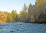
Lewisville Park, WA

Directions:
From Portland take I-84 East then take exit 8 to merge onto I-205 North towards Seattle.
Drive 8.4 miles on I-205 North over the Columbia River into Washington and take exit 38-B to merge onto SR-500 E.
SR-500 curves and continues on NE 117th Ave.
Drive 10 miles north noting The same road turns into NW 10th Ave. in Battle Ground and Lewisville Highway after Battle Ground. After passing through Battle Ground, cross the east fork of the Lewis River and turn right at the sign Lewisville Park.
History:
Lewisville Regional Park is Clark County’s oldest park and is often considered its flagship park built by the Works Progress Administration in 1936. The park was added to the National Register of Historic Places in 1986. The park is 154 acres in size and has about a mile of frontage on the east fork of the Lewis River.
There are several places to park and there about 9 free spots just outside of the park but those are usually full. Parking is $2 for a motorcycle, $3 for a car, or $30 for a yearly permit.
A good place to start is the first large parking lot on the right. There is a little covered bridge with the trail going uphill to join the main loop trail.
Length and Elevation:
2.8 miles. Elevation at the trailhead is 115 feet. Lowest point is 35 feet. Highest point is 235 feet. Total ascent is 330 and total descent is 330 feet.
Trail:
Lewisville Park Trail.
There is at least one geocache for this trail at: N 45° 48.833 W 122° 32.587 Info at Geocaching.com
Trail Maps:
Topo Map, Download Garmin .gpx file, Open Garmin .gpx file
Review: March 26th, 2020
From the parking lot walk north across the main park road, cross on the little covered bridge, and walk up the hill on the well gravelled trail.
Bear to the left and continue fairly steeply uphill and turn left at the wide, gravelled, main trail to start the loop.
The wide path goes along the edge of the park and goes up and down over the uneven terrain. The northwest part of the park isn’t really quiet because it is close to the highway. Pass through a semi-dense second growth forest of Douglas fir, maple, and alder trees. Some of the trees appear to be 70 to 80 years old. Soon you’ll drop down to the entrance road to the park. Stay on the trail which is on the right side of the road until you get to the main park entrance sign.
Cross at the main entrance sign made from large stones and logs. The trail continues diagonally to the right then curves to the left as it drops down to a large field with a small playground.
Turn right when you get to the paved road and cross a bridge over a seasonal stream which leads to a large parking area. Turn right and go down to the end of the parking area to continue the trail. You’ll pass a large field on the left and in about 300 feet, continue straight on a smaller path which loops around and rejoins the main path. This next section is very flat and you pass numerous picnic shelters and some bathrooms as you walk along the river.
After about 0.5 mile you cross back over the seasonal stream and continue right along the trail.
At the next large junction turn right again, heading towards the Lewis River and continue to parallel the river. There are plenty of places to wander down to the river and listen to the very pleasant sounds created by the small rapids.
Continue along until the path merges on to one of the park roads, go a short distance further, then turn left and take the path up the hill. The path is just before the Hemlock shelter, which has the name and a large “H” on the shelter. You’ll pass by some restrooms which are open seasonally.
Climb up the hill and enjoy the wide variety of plants in the understory. There are Trilliium, Salal, Bleeding Heart, Swordfern, Indian Plum, Coltsfoot, Miner’s lettuce, Bedstraw, Stinging nettle, yellow violets, snowberries, piggy-back plants, kitten tails, and trailing blackberries.
Take the next gravelled trail junction on your left to drop back down to the little covered bridge and the parking lot.
This trail is great for kids and dogs. In summer the river level lowers and the current slows and children play on the shore of the river. This park is very popular in the summer and fills on weekends.
Enjoy the photos!!
Gallery Pics
Switchback Steve
