
Vicinity Location: About xx miles northeast of Portland, OR in the Gifford Pinchot National Forest.
Directions: From Portland: Drive east on I-84
A Northwest Forest Permit or America the Beautiful needed to park
Bathrooms at the trailhead
Fill out a free wilderness permit at the trailhead.
Length and Elevation:
Xx miles roundtrip. Elevation at the trailhead is xx feet. Total gain is xxx feet and loss is xxx feet. Highest elevation is zzz feet and the lowest elevation xxx feet.
Trail Maps:
Topo Map-future, Download Garmin .gpx file-future, Open Garmin .gpx file-future
Trails:
Review: xx, 2024
After reaching the Berry Patch Trailhead, you walk a bit to sign and fill out a Wilderness permit. The trail on the left is the goat Ridge Trail.
The trail starts at moderate steep grade through a forest of hemlocks and cedars with an understory huckleberries and B
beargrass. The sun-dappled trail appears to be well-maintained at the time of this review with all the water bars cleaned out to reduce trail erosion.
After climbing for 1.7 miles you come out to a viewpoint overlooking Goat Rocks. From here you drop briefly and then begin climbing again, but the worst of the climbing is over.
The trail climbs up a rocky little ridge and then drops down into Jordan Creek Basin.
Just before you have hiked 4 miles you break out of the trees into the Jordan Creek Basin. In the summer the slopes are covered in blue asters, and in the fall, the mountain Ash berries and the old mans beard making an appearance. Soon you have a good climb up into the basin.
There are several little streams in the basin and just as you enter up on the left, there’s a promontory where there are several exposed campsites. There’s also a little seasonal pond, though I don’t think I would want to filter water out of it.
I did fill up with water here in case Hawkeye point was dry. after that climb out of the basin switch backing up over the northeastern lip of the basin.
Hawkeye point had plenty of little streams where I camped.
About climbing Hawkeye and divergent trails.
Day two
I waited for the rain to let up then packed up camp after breakfast and headed down to the junction for the gold Lake Trail. It is a fair Lee fairly easy trail for the first couple of miles as it skirts the head of a large river basin. Mount Adams is your constant companion to the south on a clear day. About a mile past goat Lake, maybe three-quarter mile you cross the stream and then is you climbing up you could see a lot of marmots. This seems to be, a good place to see them continue along the trail gently dropped down and you are looking for the cut off to the Packward glacier Trail.
Passing beneath the mountain ridges, there are several mountain streams bounding down the hill side. All the water makes for some of the nicest wildflower displays in a mountain side. You are likely to see.
At about 1.7 miles take the Packwood glacier trail, which starts out as a track going straight up the hillside to the left. I think having a GPS is essential to take this trail.
After crossing a small brook, the trail seems to be confused. However, junction to the left is actually the trail. If you continue onto the right, you’ll climb up to the next rise and once you get up to that rise, there is a camping area, but you, but the trail is about 200 feet to your left. Walk along this mostly level rocky shelf and you will recover the trail.
The trail begins another steep climb, passes through a lovely Heather Meadow, and comes out to a base of a rocky scree slope, which you need to climb over the top of to continue on the trail. Keep an eye out for a faint Trail, climbing up through the Heather to a small hanging valley.
At the end of the hanging Valley is another climb up a steep slope to another hanging valley. After that, you continue climbing and come out to a rocky spine. as you follow the spine up it’s steep and narrows and is covered with shingle like rocks. Continue climbing deeply up above the pack wood glacier and finally you reach a fairly flat section. You are now not far from the Pacific Crest Trail.
You will pass a couple of campsites here, which have terrific views on a nice day, though no water.
Your reacher Junction for the Pacific Crest Trail or the old snowy alternate. The Pacific crest Trail looked in terrible shape passing beneath old snowy so you should probably take the alternate route. This is a long climb up over the shoulder of old snowy, but the trail looks to be much better.
If it’s a nice day, you could take a side trip up to old snowy, which is supposed to be an easy scramble.
Once you start descending, the trail gets very steep and rough and then narrows as it goes down a spine of old snowy.the trail dropped down quite way before rejoining with the Pacific Crest Trail Association.
The next mile or so is the knife edge section. The trail here is steep, narrow, and can drop 100s of feet on either side. Pass this section with care as this is also a very rough trail in spots.
Once you are past the knife edge, you reach the junction for the Coyote Trail #79. Continue on the Pacific Crest Trail Association as you start to. drop down about 1/2 to three-quarter mile to where there are some nice campsites on the left and water nearby. Some of these campsites have a beautiful view and make for a great destination for the second day. Verizon service had two to three bars. The next morning was clear and calm with the sun shining on a nice spot of rocks to have breakfast.
Day 3
Beautiful climb out of camp and back over the knife edge. It was early, so there was time to take the snowy mountain Trail and scramble up to the peak.
Most of the trail to the peak is really easy, but there is one place where you have to climb up some rocks. It’s a great view from the top and you need to remember to see the way you went upso that you can find your way back down.
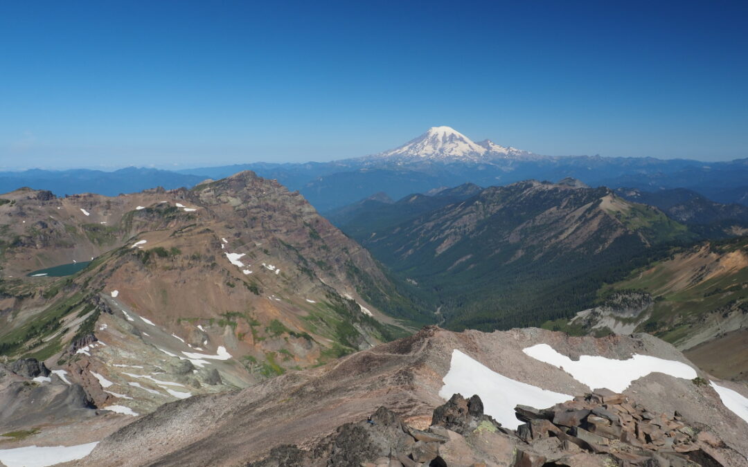
After that it was an easy walk with beautiful views of Mount Rainier Mount Adams down to the snow grass Trail number 96. Turn right here and head through snow grass flats
About a half mile down the snow grass Trail there is a small stream that seems to run all year. There are also several nice campsites, longest stretch of trail. Soon after send down some gentle switchback backs through a forest of Hemlock Noble, furs and a few pine trees.
Yeah, about a mile you will come to a large clearing with several Trail junctions. There is an unmaintained trail to your left. It goes through the woods to a very nice all your stream if you need water.
at the clearing, head straight across and back into the forest to stay on the trail. Other trails lead to a network of campsites in the area.
Drop down several switchbacks and the fourth changes into Hemlock, Cedar and Douglas fur. You pass along the raging snow grass Creek then continue down to a tributary to the Cispus river.
About 2 miles from the trailhead, you start a climb, a moderate climb and gain about 150 feet in elevation through shady forest.
Continue along the brushy path past a small lake back to the trailhead.
Recent Comments