Cutthroat Pass, WA
Vicinity Location:
About xx miles north of Portland, OR in the xx Forest.
Directions: From Portland this is a very long drive. Search Google Maps for “Cutthroat Trailhead”. Searching for Cutthroat Pass directs you to a different trailhead.
Length and Elevation:
16 miles roundtrip. Elevation at the trailhead is xx feet. Total gain is xxx feet and loss is xxx feet. Highest elevation is zzz feet and the lowest elevation xxx feet.
Activities allowed or Hiking equestrian on mountain bike bike
A Northwest for permit is required to park.
There is a pit toilet at the trailhead.
Parking gets very crowded during peak larch season in the fall. Plan to be at the parking lot before 9 AM.
Trail Maps:
Topo Map-future, Download Garmin .gpx file-future, Open Garmin .gpx file-future
Trails: Cutthroat Lake Trail #483, Pacific Crest Trail #2000
Review: 10/6/2024
The trail starts off crossing a creek on a sturdy steel bridge. From there, it climbs fairly gently for the 1st mile or so passing through a couple of switchbacks. Walking up through the first valley fall colors mango in with the Evergreen Alpine forest.
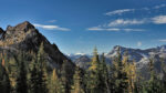
Through brakes in the trees, you can see the rugged mountains that ring this valley.
The Trail is very wide and very well used. It is rocky in places, but a lot of it is good tread.
After about 1.7 miles you come to a trail junction to cutthroat Lake on the left. There is a sign telling you no camping within 1/4 mile of the lake. Take the junction to the left and drop down to cross a small stream.
When the trail reaches the lake, enjoy the wonderful views and hope for a calm day when beautiful mountains and larch trees are reflected in the lake. From here continue along the shore of the lake wrapping around and then crossing the small cutthroat creek here you can easily find the trail on the other side of the creek and begin Your hike towards cutthroat pass.
You leave the larches for a bit and walk through a forest of mostly hemlock and Douglas for.
You soon reach another trail Junction and began ascend at a steeper rake. You’ve reached the beginning of the climb up to the past. Cross two tiny creeks and continue on this heavily used trail.
After about 3.8 miles you come to a rocky section of terrain where there is sparse tree cover, and a view to the mountains in the southeast. At the end of this clearing are a few nice rocks to sit on and enjoy the view.
Continue climbing up the switchbacks with the views improving as you get higher and higher about 5 miles you are pretty much in larches all the time. Continue up to the junction with the PCT and walk along the ridge on your left. You can walk a mile pretty easily to a great lunch spot with some flat rocks to sit on and enjoy the incredible almost 360° views. You can continue on further along the ridge, but it gets steeper and the rocks here are more of a scramble.
Walk back along the ridge to the junction of the PCT and the cutthroat Lake Trail. Turn left to head north for a bit and enjoy more larches with a fantastic backdrop of glacier peak in the distance before returning back to the junction to get the full impact of the larches.
Return again to Cutthroat Lake for a last view of this lovely mountain lake.
Hiking at the peak of larch season qualifies as one of my top ten hikes.
Enjoy the photos!!
Gallery Pics
Switchback Steve