
Cooper spur
Paved 1.4 miles
The road gets narrower and bumpier the closer you get to the trailhead. About a half mile before the parking area is a road junction where you take a sharp turn to the right and continue uphill.
The Cloud Cap Trailhead overflows with cars on nice summer weekends, but on a Monday the parking lot was about half full.
There are bathrooms and a water spigot at the parking lot.
A Northwest Forest Pass or America the Beautiful is required to park here.
Fill out a Wilderness permit at the trailhead.
From the parking lot, walk through the campground and take the obvious trail to the Wilderness permit box.
From the trailhead, turn left and start climbing uphill through an old growth forest of silver firs, walking through the picnic area and campground area to the junction with the Timberline Trail. Head left and uphill for a short distance to another junction, where a spur trail to the South Eliot Glacier Moraine heads off to the right.
Turn left to stay on the Timberline Trail, following the sign pointing to Gnarl Ridge. Pass through a nice old growth forest of huge mountain hemlocks as you climb into the upper reaches of Tilly Jane Canyon. The trail has a consistent grade here and it travels over soft volcanic ash for the first mile so expect to make a little dirt cloud as you walk along, and that fine dirt will sift into your shoes and socks.
In 0.6 mile, turn a corner and Mount Hood looms above you and the stream in Tilly Jane Canyon gurgles below. On a sunny day this is definitely a place where sunglasses are a necessity for most everyone.
Snow lingers here at on this side of the mountain at this elevation so if you were hiking early in the year watch for cairns with wooden posts to mark the trail.
The sandy trail becomes progressively rockier as you switchback up the exposed hillside. Views of Mount Hood are your constant companion along this section.
Continue climbing up the trail through a patch of mountain hemlock and whitebark pine where branches show flagging from the high winds that sometime buffet the mountain.
At 1.2 miles you come to a four-way junction with the Tilly Jane Trail. Turn right and go uphill, leaving the stone cairns and wood posts behind. Cooper Spur is the hulking, rocky ridge straight ahead, but after 100 yards on this trail, watch on the right for the short trail to Cooper Spur Shelter at the 1.3 miles from the trailhead.
Walk to the shelter on one of many informal paths, and take a moment to appreciate the architecture and construction. This stone building has existed was built more than seventy years ago and has weathered winter storms and avalanches that have gradually destroyed most of the other shelters on the Timberline Trail.
The shelter has an open door, a roof that drips when it rains, a dirt floor that slants, and a fireplace with chimney that is falling down. There isn’t room for more than a few people, but it could be very useful in a storm. There are also a number of places to pitch a tent nearby. The closest drinking water is down the trail in the Tilly Jane Canyon. Though there is a spring 1.3 miles south on the Timberline Trail.
After pausing to enjoy the shelter, return to the main trail and continue the remaining 0.8 mile climb toward the looming crest of Cooper Spur. Though the trail quickly gains elevation, the grade is always good as the trail climbs through sparse flowers and plants.
At 1.8 miles you reach a small trail junction that heads over to an overlook of the canyon.
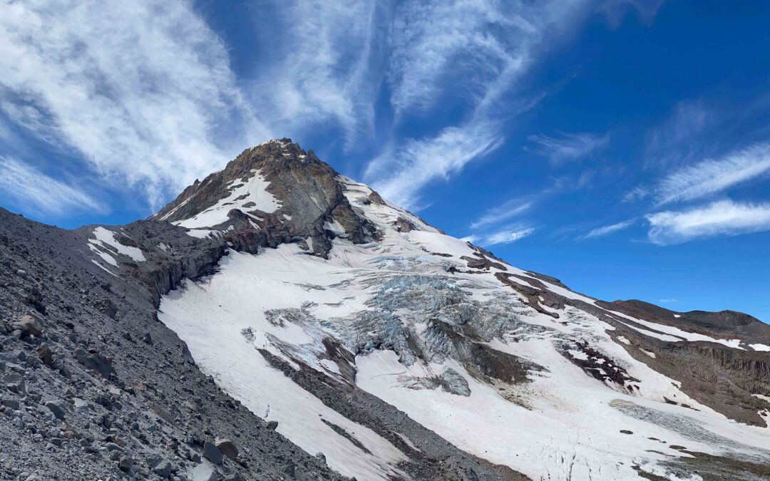
Soon the trail starts climbing a series of increasingly steep switchbacks, passing awesome viewpoints of the north face of Mount Hood and the rugged icefalls and crevasses of Eliot Glacier.
About 3 miles into this hike I hit a snowfield at the time of this review. The snow was hard enough to where I did not want to try to make kick steps and instead navigated uphill through the rocks and sand to the right and found a bit of a user Trail. I crossed over the snowfield on a gentler slope and softer snow and rejoined the trail.
As you near the crest, a final set of switchbacks brings you to views south of the Newton Clark Glacier, which is the third largest glacier on Mt. Hood. Soon you reach several climber’s windbreaks of piled rocks. From here, the view extends from Mount Jefferson to Mount Rainier, and includes a good portion of the Columbia Plateau to the east.
Look for an inscription from an early 1900s Japanese climbing party on a boulder near the trail. This makes a good stopping point to relax and admire the view. From here continue up past Tie-in Rock which is an obvious rounded boulder right on the crest of the ridge. This is where climbers going up this route traditionally rope up. Beyond Tie-in Rock walk up the steep ridge to another high point which has views of the Newton Clark Glacier and Eliot Glacier.
The day of this hike, there was a distinct smell of sulfur for the past few hundred feet of elevation approaching the turnaround point
Just before the turn-around point on Cooper Spur is a bronze plaque attached to a large boulder commemorating some people. There is a piled rock windbreak on top. Beyond this high point, dangerous rockfall is common in the summer and fall.
Sign the cache if it is still there.
Retrace your route and tell you see the Cooper Spur shelter. Turn left here and follow a trail that climbs gently up to a ridge above the Elliot creek. You can see it’s brown water rushing below you. Follow this ridge back down to the cloud cap Cooper Spur trailhead.
Enjoy the photos!!
Gallery Pics
Switchback Steve
Recent Comments