
Vicinity Location: 51 miles northeast of Portland, Oregon in the Mt. St. Helens Monument.
Directions:
From Portland, OR, take I-205 north to exit 30b to Battle Ground. Move over to the middle or left lane and proceed north on SR503 for about 10 miles to Battle Ground. Continue north on SR503 past Chelatchie Prairie and Amboy. At the junction of Lewis River Road and SR503, turn right and continue on SR503 past Cougar. Make a left turn on to FR 83 and follow the signs to the Ape Canyon trailhead.
A Northwest Forest Pass is required at this location.
An outhouse is available at the trailhead.
Length and Elevation:
11 Miles round trip, Elevation gain 1,700 Feet and loss 300 feet to the turn-around point. Total gain and loss is 4,000 Feet. Elevation at the trailhead is 2800 feet, the summit elevation is 4,100 feet.
Trail:
Ape Canyon Trail, #234 with connections to Trail 216.
Trail Maps:
Topo Map, National Forest Service Map, Download Garmin .gpx file
Review: June 26, 2005
Trails within 10 miles of Mt. St. Helens were closed in October 2004 due to the renewed eruption activity. Most trails, including this trail, were reopened in the spring of 2005. Trail 216 across the Plains of Abraham was reopened in 2007. The trailhead parking lot is rather small and holds about 10 cars. There is overflow parking on nearby roads. The trail begins from the right side of the parking lot. The first ½ mile of the trail is rutted in the middle from mountain bikes but the trail smoothes out after that. The trail generally climbs and follows a ridge. There are views of the lahar and Mt. St. Helens but the trail is mostly in the trees.
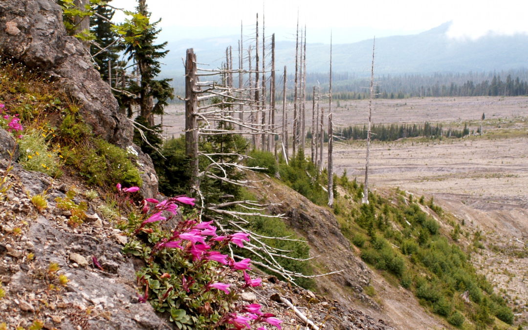
After about 1 ½ miles, the trail switchbacks up a hillside to the top of the ridge. The trail continues uphill with occasional dips as it follows the profile of the ridgeline. There are quite a few small wildflowers in spring. Anemones, white orchids, and candy flowers are in the woods and red Indian Paintbrush is plentiful on hillsides and above the timberline. The first part of the trail goes through second growth and you can see stumps from logging operations of long ago. Higher up the ridge, the timber changes to old-growth trees of fir hemlock.
The trail is well maintained and all of the deadfall has been cleared from the trail. Towards the high point of the trail, it crosses over the ridge and has eastern views. The skeletons of the trees in the 1980 blast zone can bee seen through breaks in the forest canopy. The trail crosses over the ridge again and you see the lahar and Mt. St. Helens. The composition of the trail changes from being carpeted with fir needles, to the trail becoming looser and pumice rocks appearing. The pumice shows up in increasing amounts until the trail crosses over back to the east side of the ridge. Here the trail is packed dirt and has a rut down the middle from the mountain bikes. Rounding the corner, you see Ape Canyon.
Ape Canyon is a narrow slot canyon created by floods that gouged through the rock. The trail rounds another corner and meets up with the junction of trail 216. Here is a field of Indian Paintbrush on a flat pumice plain. There is a good chance no water will be available on this trail. You can get water at Moss Springs, which is near the trailhead. You could combine this trip with the short loop on the Lava Canyon trail #184. There are no restrooms at the parking lot. Drive or walk over to Lava Canyon trailhead for restrooms.
Enjoy the photos!
Gallery Photos
Switchback Steve

Recent Comments